Menu
Menu
I seek a world where the Mississippi is once again respected as many connected rivers, no longer weaponized, whose caretakers are always de-paving and returning the shell, mangrove, and wetland flood controls, in collaborations across cultures and among communities with the common purpose of sponge.
Margaret Pearce
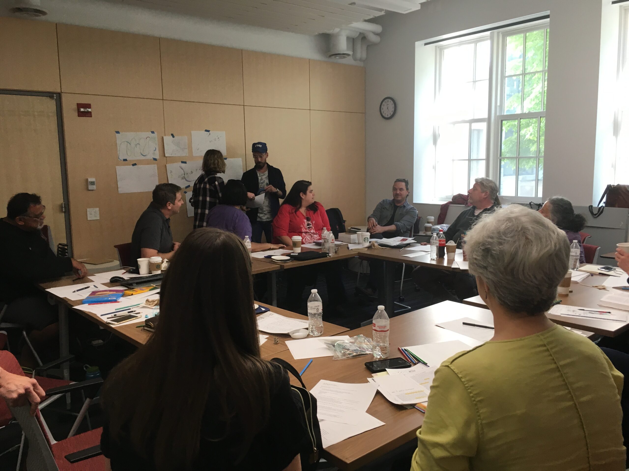
Margaret Pearce is a Citizen Potawatomi tribal member and a cartographer living on Penobscot homelands in Maine. She joined us in spring 2019, in Chicago, to lead a mapping workshop and to discuss her work in progress, called Mississippi Dialogues. She and Kelly Wisecup returned to our conversations in spring 2022, carrying on our dialogue in emails exchanged over several months.
KW: As a professor and then full-time cartographer, you’ve worked with tribal nations, museums, and news media to create maps that depict homelands, waterways, and the stories connected to those places, Many of your maps are printed and quite large. Why have you chosen cartography as your medium of expression?
MP: I loved cartography from the moment I began studying it seriously in my twenties, so I must have loved it before then, too. The feeling has never abated. It’s a form that makes total sense to me, while also always eluding me, and I just keep following it to find out where it’s going. I see it as a form of writing that works in parallel to and complements writing in linear text. By bringing special qualities to the table, like simultaneity, interrelationship, and situatedness, to name a few, it has the capacity to reveal the proximate dimensions of narratives that a person might miss in written text.
As for print, I’m mesmerized by the way print cartography portrays space and makes space, in that dialogue and energy between reader, cartographer, and map. It’s ruminative, tactile, associative, persistent. It gives us time to absorb the unfamiliar, because we can hear what is being said in our peripheral vision before we’re brave enough to face it, and let it expand what is already familiar and comfortable. I’m just endlessly interested in that.
KW: Simultaneity is something I’ve thought lots about with in my work on Indigenous compilations (texts made when Native writers intentionally assembled pieces or extracts of other texts, like word lists, recipes, and scrapbooks). I love how your thinking about cartography as a form that brings simultaneity, interrelationship, and situatedness to the table can help us think about how maps—and other textual forms—represent space, narrative, and relationships.
MP: I would love to hear more about that. How is simultaneity in compilation like simultaneity in cartography?
KW: I understand Indigenous compilations as forms that take the space of the page—rather than the sentence or paragraph—as a framework for meaning making. The textual elements assembled on the page—single words, longer excerpts of text, images—create meaning out of the spatial relationships they accrue by virtue of being placed in proximity to each other. There’s a great description of this from historians of science James Delbourgo and Staffan Müller-Wille: they call lists “conceptual propinquity engines” in their introduction to a 2012 special issue of Isis entitled “Listmania.” I love this phrase as I think it gets at the ways that lists and other compilations are engines of proximity and of relationships.
MP: The accrued meanings of spatial relationships in proximity… that is so much like cartography! What about the courage—and by extension, responsibility—dimension of proximate relationships? Do you see that in compilation, too?
KW: Yes! I love what you say above about how cartography “gives us time to absorb the unfamiliar, because we can hear what is being said in our peripheral vision before we’re brave enough to face it, and let it expand what is already familiar and comfortable.” While many Indigenous writers made compilations in the 18th and 19th centuries, I had not seen them as part of Indigenous literary archives in part because I was trained to see certain genres (autobiographies, novels, letters, etc.) as “literary,” and because I wasn’t sure initially how to think about these compilations forms that seemed so utilitarian (lists, account books, catalogs, recipes). But I came to see how Indigenous writers used elements of simultaneity and proximity to make relationships on the page that in turn also generated relationships off the page. For instance, I look at the poetry albums of the Ojibwe woman Charlotte Johnston, which she kept in the 1820s at the Sault Ste. Marie, on the river now called the St. Mary’s river, which connects lakes Superior and Huron. Her friends and family members wrote poems in these books, and visiting Ojibwe ministers recorded hymns in Anishinaabemowin in them, too. Her books make relations among the poems and hymns recorded in them, and the books reflect and fostered relations among the people who contributed the poems. We can also think about how the books supported additional actions–like hymn singing, poetry reading, and sharing texts. We get glimpses of Charlotte’s participation in these actions from the journals of British and American tourists, who complain about Ojibwe women visiting Charlotte for things the tourists viewed as unimportant. But if we read them against the grain, these depictions reflect the community that Charlotte fostered through sharing songs and by providing hospitality to other Ojibwe women.
MP: It seems like there must be a brevity dimension in there, too, no? The brevity of both compilations and poems, the way that brevity makes room for the Reader, the obligations that are born and then borne.
KW: Hmmm… yes, I think that Indigenous compilations obtain much of their meaning in how they are read and used. How Charlotte or an Ojibwe minister like John Sunday (who contributed a hymn in Anishinaabemowin to one of her books) might give a written hymn life by singing it, and how that singing might differ depending on who was present, who else is singing, where one is singing. Brevity too in that the page is not the only or even the most important space for communication—it might be a starting place or a place to experiment with creation or translation, and it opens into other kinds of exchange and communication.
To loop this back to cartography, I read your article “The Last Piece is You,” published in The Cartographic Journal on the map you collaborated on with the Penobscot Nation, at a key moment in my thinking about Indigenous compilations. Your article helped me think about how printed materials can make relationships off the page, among peoples and places. How did you come to understand what maps do on and off the page?
MP: For the project you mention (Iyoka Eli-Wihtamakw Kǝtahkinawal / This Is How We Name Our Lands), there was and is a Penobscot tradition of place-based narratives for teaching and remembering knowledge about how to live and how to navigate unfamiliar waters. To listen is to piece together a landscape of stories, place names, and canoe routes, which they then complete by navigating through and to those places themselves. It’s the listener–traveler who activates meaning from the associations between places by picking up their obligation to go there. Gradually I came to understand my role as outsider and cartographer was to pay attention to the qualities and structure of that experience and find a way to translate it into the design of their printed map and guide.
In my more recent work experimenting with wall-sized maps, I’ve been delving deeper into the map as itself a place for co-constructing situated knowledge. By making a space large enough for several people to stand and read and talk together from different locations in the design, there’s room for those “off the page” relationships to form right there as individuals pick up responsibilities they recognize as uniquely their own.
KW: Why do you see cartography as important for building climate dialogue about the Mississippi?
MP: Cartography can expand our notions of who the River is to begin with. An Army Corps map portrays the Mississippi entirely through the categories of their flood control structure. If that’s our point of beginning for dialogue, of course it will be difficult to imagine or remember the River differently. If instead that dialogue begins from a map of Dakota or Ho-Chunk names for their places along the River, the conversation can begin instead from a much older Mississippi, where flooding is described in the context of the arrival and departure of glaciers. Cartography can then take it further by combining time scales, remembering, imagining, and experiencing can nourish each other and flourish.
KW: Speaking of which, in the summer of 2019, you traveled up and down the Mississippi to do just that: ask permission for working with each Nation’s place names along the River. How did that trip influence your intentions for the map? What did being on the River help you to understand?
MP: I’d thought that time would largely be devoted to introducing and discussing the project, and yes, asking permissions for place names to include in the map. (Place names are signage for Indigenous ways of knowing and living at a particular place, so, they are essential generators of Indigenous worlds on the map.) Yet for most of the Nations whom I was able to visit with, our conversations focused more on language about water and their histories of living with different river sections.
KW: That is really interesting. Why was that, do you think?
MP: I think it was partly because place names are protected cultural property, and not the business of an outsider intruding on their homelands. Speaking about their relationship with the River over time is probably a better starting place.
When we did talk about the names, the fact of being there on the River illuminated so much about their meanings. For many Tribes, what Anglo-Americans named the Mississippi is actually many different rivers with their own names and qualities. Standing at the river confluences and lake outflows where the names change gave me a sense of those differences, which in turn will help me understand how to shape the narrative and composition of each map panel. Of course I also visited as much of the flood control structure as possible, but my priority was to look for better understandings of the Indigenous geographies.
I’m curious to hear your experience, too, because you also traveled up and down the River as part of the HWW collaborative. How did it change your understanding of Indigenous literatures of the Mississippi?
KW: One of the things I loved about our collaborative is that it gave me the opportunity to think deeply with writing about rivers, especially poetry. I think here about Heid E. Erdrich’s poemeo (poem-video) “Pre-Occupied,” which reminds us not just that “there is a river to consider” but also that the “there’s a river that considers us.” The poemeo beautifully represents the relations between the river and constellations, the threats to rivers and Indigenous peoples’ relations with them, from pipelines and drilling, and the U.S. settler public’s distracted apathy about such threats. And then toward the end of the grant, Natalie Diaz’s Postcolonial Love Poem was published, and I’ve been thinking with her work “exhibits from The American Museum of Water.” I love the opening lines from Diaz’s poem; “I can’t tell you anything new about the river–/you can’t tell a river to itself.” Can we think about poems as one of the ways Indigenous peoples continue their relationships to rivers, in spite of dams and dredging and settlers renaming and reversing rivers? Being in place –going to visit the river along its route and being together on the river with the other grant members and visiting artists —was essential for glimpsing even a small piece of those relations.
MP: I love that the lines you quote as meaningful and exciting to you, from both Erdrich and Diaz, speak about the river as our relation, as animate being with whom we’re in relation. It makes me reflect on your parallel readings of Charlotte Johnston’s poems as engines of relations. And reminds me that poetry, like cartography, is also a form for uncovering and expressing the situated, simultaneous, and proximal dimensions of experience.
What happened to essential being-in-place when the pandemic hit?

KW: So much of the learning that happened as a part of this grant happened in place: we met three times along the river throughout the course of the grant. I’d worry about how the grant was going, and then we’d come together with each other and the river, and then the stakes and nature of our collaboration would suddenly be much clearer. Place had a way of snapping relations and priorities into clearer view. So not being able to travel was a real setback. But we’ve met monthly on zoom to work on this website. Those meetings required us to figure out how to work together across distances of place and time zones. That meant seemingly basic things like setting clear deadlines since we couldn’t count on being together to generate ideas or writing, and it also meant more enjoyable actions like writing the keyword essays together. And for me, it meant paying close attention to making sure our process remained collaborative—from things like who facilitated our meetings (we ended up taking turns) and who was doing the heavy lifting in the co-written keyword essays. I’m grateful for the process-oriented lessons that I’ve learned, even though I can’t wait to reconnect with you, the grant members, and others in person.
And it sounds like the pandemic prevented you from working on Mississippi Dialogues in person and in place. But did it continue to influence your practice?
MP: The pandemic serendipitously brought an invitation to collaborate with Josie Lee and Bill Quackenbush from Ho-Chunk Nation, Sunshine Thomas-Bear and Carolyn Fiscus from Winnebago Tribe, and Diane Hunter and Scott Shoemaker from Miami Tribe, on an exhibit about Removals for the Field Museum. The Mississippi figures prominently in both Ho-Chunk and Myaamia accounts of their Removal experiences, but not in the same ways. Those accounts and their differences were important instruction for me.
The work also gave me the chance to explore some of the design ideas that shape the Mississippi project. For example, we began by recording conversations and then started building the map design from the words in those recordings. Other examples include: collaboratively revising text directly in the map; interweaving Indigenous and non-Indigenous geographies to clearly situate map readers in a space of accountability; and large-format cartographic installation as soft meeting place for talking about events and conditions that are hard to discuss. These ideas and techniques were central to the Removals collaboration. I can continue to develop and learn about them for Mississippi Dialogues.
KW: At our gathering in Chicago, you led us in a workshop called The Map Your Text Makes, encouraging us to draw out the spatialities in a literary text selection, and map them. What do you see as the value of this work for the humanities?
MP: The seeds of that workshop come from my graduate days at Clark, where I had the privilege of studying with John Conron in the English Department. He gave us a page of text and asked us to write about every spatial relationship we saw there. I initially focused on the spaces manifested in what was described or discussed in the narrative. From his teaching, though, I learned to expand those interpretations to include the interrelationships of words, letters, and sentences. It totally opened my eyes. The Chicago workshop begins from that structure and then moves it into mapping. I thought it would be a way for us to begin from a familiar place—with close readings of texts—then learn how to translate those readings into cartographic language. The point was to make invisible or unacknowledged spaces, categories, and relationships legible. I feel that kind of approach is valuable because it draws on analytical methods you‘re probably already using for literary work and then widens the circle to make a connection to cartographic language. So from the beginning, you understand writing and cartography as a continuum.
KW: I think I’ve mentioned this to you in emails, but this workshop entirely changed how I read and teach Black Hawk’s Autobiography. As part of the preparation you asked us to do for your workshop, I reread the Autobiography and circled every mention Black Hawk makes of rivers. And I could feel my whole sense of that Autobiography changing as I did so—I suddenly could see how central rivers are to the text and how Black Hawk is showing how Sauk understandings of rivers as homelands are in conflict with U.S./settler ones of rivers as colonial boundaries and transportation corridors. When I taught the Autobiography after the workshop, I began asking my students to work together to circle all the references to rivers in a section of the text and then to make a “map” of what they find—I let them interpret “map” as they wish. I am always delighted by what they make: they’ve made mobiles that represent the river and its different seasons; they’ve made layered maps showing how settler cartographies are being placed over Sauk ones; they’ve made ceramic scenes showing Sauk environmental relationships. Your workshop opened up how maps can be a way of reading for relationships.
I wonder how you think about those relationships and how to represent them cartographically when we’re seeing those relationships being rapidly reshaped by climate change?
MP: Wow, mobiles and clay, that is really beautiful. I’m thrilled that you further transformed the workshop into an entirely new way for students to respond to the text.
The relationships are always reshaping, just like the workshop. My purpose for Mississippi Dialogues is to re-center relationships in balance, by reminding readers that they are there.
KW: What kind of future would you like to envision for the Mississippi?
MP: I seek a world where the Mississippi is once again respected as many connected rivers, no longer weaponized, whose caretakers are always de-paving and returning the shell, mangrove, and wetland flood controls, in collaborations across cultures and among communities with the common purpose of sponge.