Erosion 1a) The action or process of eroding; the state or fact of being eroded. Erode To gnaw away; 2a) To wear away; to eat out; 2b) To form (a channel, etc.) by gradual wearing away.
Erosion is the process by which soil and rock particles are worn away and moved elsewhere by gravity, or by a moving transport agent – wind, water or ice.
Erosion
by Bonnie Etherington, Phillip Round, and Kelly Wisecup
Erosion as a Hydrological Feature
Erosion is a process of wearing, gnawing, and eating away, as well as a process of forming. It is a process of removal and displacement that can also be one of making. Erosion involves muck, sediment, dirt—the particles being eroded—on the one hand, and the water which moves those sediments and remakes them into new landforms on the other. Erosion transforms the Mississippi River’s channels, which are reshaped, worn down, and built up as currents, floods, and rivulets remove and transfer banks, sandbars, and shorelines. As one part of the processes that deposited agriculturally rich sediment throughout the Mississippi River Valley, erosion determines where people live and plant, but it also carries toxic runoff and pollution downstream. As a hydrological feature and a political one, erosion makes possible human industry and agriculture, even as it is also a consequence of human actions to transform the River Valley into a corridor for capital.
Erosion as History
Over time, riverine erosion leaves traces of its movement in the form of what hydrologists call a meander. A meander is one of a series of regular sinuous curves, bends, loops, turns, or windings in the channel of a river, stream, or other watercourse. Meanders are produced by a river as it erodes the sediment of its banks, creating concave cuts of the outer banks called cutbanks and downstream sedimentary deposits of the inner banks called bars: “The result of sediments being eroded from the outside concave bank and their deposition on an inside convex bank is the formation of a sinuous course as a channel migrates back and forth across the down-valley axis of a floodplain.”[1]
Anyone who has flown over the Mississippi has seen the many bends and curves of the river—not only the meanders of the present, but also those of the past, since the landscape surrounding today’s main channel still bears unmistakable curves and swales formed by the river’s many different courses over the millennia. In a sense, meanders, which are formed by tributaries emptying into the main river and in turn produce islands and sandbars of their own, create a historical narrative of the river’s life. Rivers, in other words, impact the human populations living in their watersheds in a variety of ways. They deposit sediments that create rich bottomlands and river islands suitable for extensive cultivation, producing a constantly changing set of boundaries between peoples and landforms.
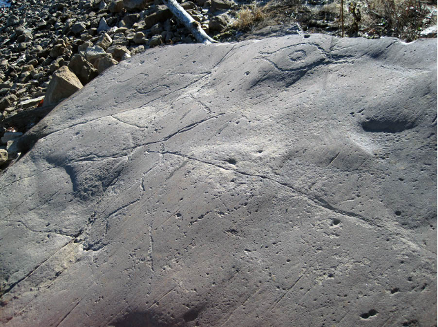
For Indigenous peoples in the River Valley, the Mississippi is the source of all life. The most famous depiction of pre-contact Indigenous appreciation of erosion and meanders on the Mississippi appears on the petroglyphic images of what is today called Commerce Rock, a series of rock art panels dating to about AD 1200 that were inscribed on quartzite boulders near the mid-point of the river’s journey to its delta.
Commerce quarry and petroglyph site circa AD 1200-1400. Photo credit: Michael Fuller.
In their essay, “A Pre-Columbian Map of the Mississippi,” anthropologists F. Terry Norris and Timothy R. Pauketat argue that the markings on Commerce Rock are “maps,” and thus contain “spatialized narratives” about their relationship to the river. One of the most prominent features of the main petroglyphic panel is a “meander line,” a “single prominent meandering line around which are arrayed a series of discrete dots, dot clusters, geometric patterns, and at least seven formal motifs.” Norris and Pauketat “believe that the Commerce rock-art panel was a map of discrete places of cultural if not political significance to pre-Columbian people traveling along the Mississippi River and stopping or crossing at Commerce.” The bottomland in which the images appear was created by long periods of erosion that laid bare the quartzite boulders on which they are carved.[2]
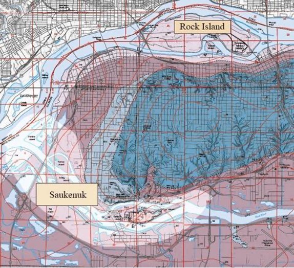
In later times, erosion also contributed to Indigenous life on the Middle Mississippi by forming river islands and rich bottomlands. A perfect example of this is Rock Island, situated on the Mississippi River between Davenport, Iowa, and Moline, Illinois. Like the fluvial buildup on the islands by the confluence of the Rock River and the Mississippi, the Sauk village of Saukenuk—known now as the town of Rock Island, Illinois—sits on a bottomland enriched by silt and sediment deposited by the process of erosion. A modern geological map of the area vividly dramatizes how the interplay of erosion, flow, and flooding supported human occupation of the site for thousands of years.
Bedrock geology of Davenport East and Milan quadrangles, Rock Island County, Illinois. Image credit: J.A. Devera and J. Krienert, Illinois State Geological Survey.
At this site formed by erosion, meanders, and fluvial deposits, Black Hawk, or Black Sparrow Hawk (Ma-kat-tai-me-she-kia-kiak [Mahkate:wi-meši-ke:hke:hkwa], “be a large black hawk”), was born in 1767 in the village of Saukenuk. At the time, the Sauk used the village year-round, building log homes, fencing in the fields, and hunting on the Illinois as well as the Iowa banks of the Mississippi. In his life narrative, Black Hawk recounts the coming of whites to this fluvial island and rich alluvial bottomland:
We were friendly treated by the white chiefs, and started back to our village on Rock river. Here we found that troops had arrived to build a fort at Rock Island. This, in our opinion, was a contradiction to what we had done—”to prepare for war in time of peace.” We did not, however, object to their building the fort on the island, but we were very sorry, as this was the best island on the Mississippi, and had long been the resort of our young people during the summer. It was our garden (like the white people have near to their big villages) which supplied us with strawberries, blackberries, gooseberries, plums, apples, and nuts of different kinds; and its waters supplied us with fine fish, being situated in the rapids of the river. In my early life, I spent many happy days on this island. A good spirit had care of it, who lived in a cave in the rocks immediately under the place where the fort now stands, and has often been seen by our people. He was white, with large wings like a swan’s, but ten times larger. We were particular not to make much noise in that part of the island which he inhabited, for fear of disturbing him. But the noise of the fort has since driven him away, and no doubt a bad spirit has taken his place!
Our village was situated on the north side of Rock river, at the foot of its rapids, and on the point of land between Rock river and the Mississippi. In its front, a prairie extended to the bank of the Mississippi; and in our rear, a continued bluff, gently ascending from the prairie. On the side of this bluff we had our corn-fields, extending about two miles up, running parallel with the Mississippi; where we joined those of the Foxes, whose village was on the bank of the Mississippi, opposite the lower end of Rock island, and three miles distant from ours. We had about eight hundred acres in cultivation, including what we had on the islands of Rock river. The land around our village, uncultivated, was covered with blue-grass, which made excellent pasture for our horses. Several fine springs broke out of the bluff, nearby, from which we were supplied with good water. The rapids of Rock river furnished us with an abundance of excellent fish, and the land, being good, never failed to produce good crops of corn, beans, pumpkins, and squashes.[3]
Erosion as a Political Feature
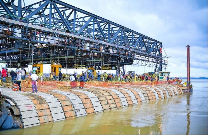
As the case of Saukenuk shows, hydrological processes of redistributing sediment have formed river islands, creating places that are Indigenous homelands. Such processes of erosion were disrupted both by the settler occupation of Native lands in the 1820s and the 1830s and by human intervention in the form of levees and concrete mats that maintain the river’s navigability. Such interventions, widespread in the nineteenth century as an integral part of settlers’ westward imperial expansion, frequently destroyed Indigenous peoples’ homelands and sacred places. The consequences of such disruptions are ongoing: locks and dams upriver capture and keep sediment, redirecting it from its travels down the river and depriving the river’s delta of the nutrient rich sediment that the land and the wetlands both rely on. Often, the materials eroded and carried down the river are also toxic, killing the beings exposed to the waste, pollution, run off, and excess that comes from cities, agricultural fields, and slaughterhouses.
Each year, hundreds of thousands of concrete squares are sunk into the Mississippi to fortify its banks and improve navigability. Photo credit: US Army Corps of Engineers.
As US settlers mapped and surveyed the lands they hoped to claim, they imbued the meander with legal significance. In US property law, a “meander line” is “a usually irregular surveyed line following the outline of a body of water that is used to measure abutting property and is not a boundary line.”[4] We can see a meander line working as a legal and political concept in a treaty signed on July 15, 1830 between the United States and the Sauk and Fox, the Medewakanton, Wahpekuta, Wahpeton and Sisseton bands of Sioux, and the Omaha, Iowa, Oto, and Missouri nations. The treaty reads:
The U. S. agree to reserve for the occupancy of the Omaha, Ioway, Ottoe, Yanckton, and Santie Sioux half-breeds the tract of country within the following limits: Beginning at the mouth of the Little Ne-mo-haw river and running up the main channel of said river to a point which will be 10 miles from its mouth in a direct line; from thence in a direct line to strike the Grand Ne-mo-haw 10 miles above its mouth in a direct line (the distance between the two Ne-mo-haws being about 20 miles); thence down said river to its mouth; thence up and with the meanders of the Missouri river to the point of beginning.[5]
In the language of the treaty, the meander line serves as a mark of property. The meanders that created Indigenous homelands thus become reappropriated and enlisted in the state’s transformation of communal Native lands into private property to be purchased and owned by settlers. Like the process of erosion, the meander is politicized and utilized as a tool of dispossession, used by settlers to exert political and commercial control over Indigenous lands. As another example, we might think of the metaphorical and physical erosion performed by settler farmers and multinational corporations who have leveled earthworks along the river to make cotton fields and golf courses, and who have destroyed sacred spaces to make room for railroads, factories, and highways.
Railroads at the Wakáŋ Tipi site. Photo credit: Kelly Wisecup.
These examples of erosion as dispossession and extraction remake relations among the river, its banks, its lands, and its wetlands, as well as among Indigenous people, their non-human relatives, and their homelands. Concerned with the impact of settlers’ dramatic reshaping of waters and lands, Potawatomi philosopher Kyle Powys Whyte describes such instances of ecological appropriation:
By seeking to establish their own homelands, settler populations are working to create their own ecologies out of the ecologies of Indigenous peoples, which often requires that settlers bring in additional materials and living beings (e.g., plants, animals) from abroad. Consider US settler colonial domination of Anishinaabewaki. The US rerouted the hydrology to facilitate its own forms of transportation and water use. The US mined, deforested, and industrialized the Great Lakes region. US settlers killed off or decimated many species and intentionally and unintentionally introduced new ones. The draining of wetlands, development of commercial agriculture and recreational areas, and building of massive urban areas and military, chemical, oil, and gas industries transformed the ecologies of Anishinaabewaki into a US settler ecology, including states such as Michigan, Wisconsin, Indiana, and Minnesota.”[6]
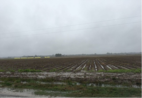
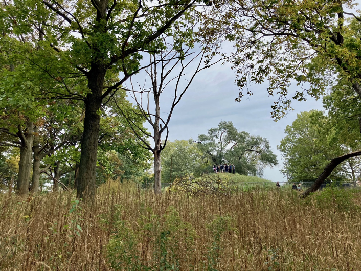
Whyte is tracing the ways in which settler ecologies emerged from the transformation of rivers and wetlands into a place for commercial agriculture. His insights became evident for our group when we stood in a sodden fallow cotton field at Carson Mounds near what is now known as Clarksdale, Mississippi. What was immediately visible was the sediment that was stuck in place—the muck in the field. Located in the heart of the Mississippi Delta, the land on which we stood had been formed over centuries by the interplay of erosion and flooding that deposited rich sediments and created oxbow lakes. Floods carrying sediment formed hills and ridges, shaping this field into a place where Indigenous people built nearly 90 earthworks in the early 1000s CE. Shaped by floods that created new landforms and gnawed them away, the landscape was in constant flux. For Indigenous people, building mounds may have been one way of interacting with and shaping these erosional processes while also creating structures that could be used for ceremonial purposes.[7]
HWW participants at Carson Mounds, October 2019. Photo credit: Kelly Wisecup.
The landscape at Carson Mounds has been nearly completely reshaped, both by later floods and the river’s movement a few miles away, and by settlers who sought to transform the earthworks into a site of agricultural production—a plantation in the nineteenth century and a node in a corporate agriculture business today. Only a few earthworks remain visible; theothers were flattened by settlers as they sought to transform this place into a field from which profit could be generated.
The leveled field symbolizes a metaphorical and physical erosion—a leveling and gnawing away—that takes place on Indigenous peoples’ homelands at the level of ecology and politics. This human form of erosion seeking to transform all available land into a surface suitable for farming is an extractive erosion—an erosion that gnaws. Such a definition of erosion locates white settler wealth in an Indigenous past, presence, and place, as well as in enslaved peoples’ labor. In a stark visualization of these layered histories, the earthwork that remains in the field today is held captive by a plantation house built on its brow. Dispossession and desecration, enslavement and extractionall remain present and visible in the muddy field in which our group stood together on a wet October day. As the example of Carson Mounds shows, settlers have sought to harness erosion as a political process with which they could claim fertile lands and transform Indigenous homes and sacred places into sites of capital.
By imposing new ecologies that control erosion in the River Valley, settlers have attempted to hold on to, stabilize, and manage the sediment the river redistributes as it makes new channels, river islands, and meanders. We have only to look downstream from the Delta and fields like the one at Carson Mounds toward the Gulf’s growing Dead Zone(s) to see some of the consequences of extractive settler ecologies for the river and the life it supports.
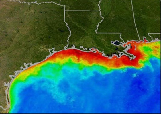
Gulf of Mexico Dead Zone. Photo credit: National Oceanic and Atmospheric Association.
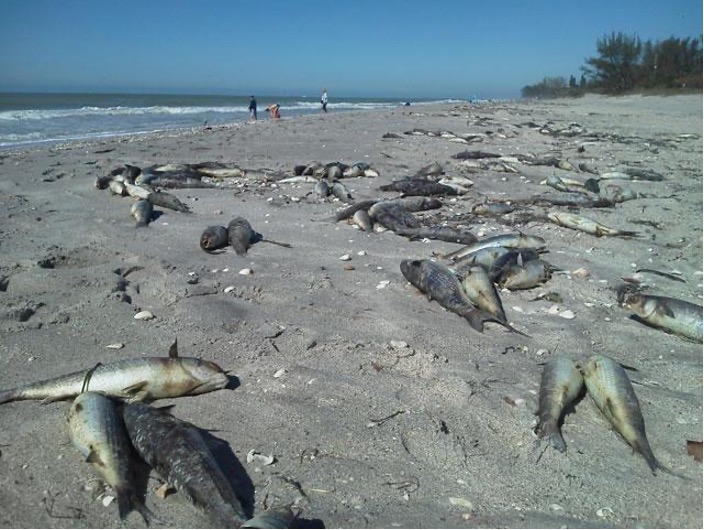
Every summer, a large dead zone or low-oxygen area develops in the Gulf, encompassing 6,000-7,000 miles. Few marine creatures other than algae and jellyfish can survive in such low oxygenated zones, which triggers large algae blooms. The Dead Zone is created by large amounts of sediment carried primarily by the Mississippi River, which includes excess nitrogen and phosphorus that runs off into the river from crops and industrial factories. According to The Nature Conservancy, improving the ways fertilizers are absorbed by crops may shrink the Dead Zone, as may repairing river connections to floodplains, which act as large filters. The Mississippi River has long had its own filtering systems for regulating itself and its relationship to the ocean, but human impact has overwhelmed them.[8] The Dead Zone and the dead fish left scattered on the beaches of the Gulf exemplify the extremes of the widespread consequences of human interventions into the various processes of erosion discussed above.
Fish killed by hypoxic conditions in the Dead Zone. Photo credit: Mississippi River Collaborative.
The Future of Erosion
Indigenous futurists like the CHamoru (Hacha’maori) and Coushatta tribe of Louisiana (Koasati) artist Santiago X are reactivating processes of erosion in ways that acknowledge it as a historical and political feature with the capacity to both form and gnaw away at land. In Chicago, Illinois, X is constructing two earthworks along rivers that flow into the Mississippi via the Illinois River, the Des Plaines River and the Chicago River. To make these earthworks, X moves and forms sediment. Acknowledging the ancient Indigenous earthworks the city has paved over, X also reminds the rivers and the emerging mounds of their deeply rooted and ongoing relationships. While grounding his work in the past, X refuses frameworks of nostalgia or replication for understanding the earthworks. Instead, he invokes the earthworks as sites of restored Indigenous ecologies where settler extraction can be made visible. He explains that his mound building is “about [Indigenous people] being able to innovate on our own land again,” calling the earthworks “destinations of contemplation—a space to think about those that we displace with any kind of urban development billed as ‘progress.’”[9] For X, the earthworks he is building reckon with the histories of extraction and colonialism that have shaped and reshaped rivers and their banks. His earthworks participate in the interplay between earth and water that form and gnaw all at once, mimicking the relations that have long characterized the Mississippi River Valley.
X’s coil mound in Chicago’s Horner Park on Indigenous People’s Day 2021. Photo credit: Sara Černe.
At the river’s southern reaches, interdisciplinary storyteller Monique Verdin (Houma Nation) documents the complex relationship between erosion, culture, and climate in Southeast Louisiana. Her work is deeply connected to Yakni Chitto (“Big Country”) between the Atchafalaya and Mississippi rivers, “a place where land is being lost at one of the fastest rates on the planet.” For Verdin, erosion and the ongoing destruction of floodwaters are inextricably bound up in oil and chemical waste in the region. In her article “Cancer Alley,” she describes how this waste has caused devastating damage to the land, peoples, and waters of the Lower Mississippi. She writes:
[R]efineries and waste pits and toxic byproducts, seen and unseen, pockmark the landscape. Along the banks of the Mississippi River, a neglected part of the United States is bearing the brunt of the shale boom as a wildfire of new construction and the expansion of single-use plastic facilities and export terminals assault an environment with long-term investments, facilitating a pattern of violence against communities for the sake of carbon profits.[10]
The future of erosion for Verdin is a complex one—while sediment flowing downriver built the land on which she lives, the river now also carries harmful toxins and other forms of sediment. As she states in her HWW interview, everything, in the end, “is tied to access to clean water and the Mississippi River, even though she has been in an abusive relationship with those who use her and do not respect the generational right of the river’s life force.”
[5] “Prairie du Chien, Michigan Territory (Statutes at Large Volume VII, 328),” Eighteenth Annual Report of the Bureau of American Ethnology(Washington: Government Printing Press, 1899), 726.
[6] Kyle Whyte, “Settler Colonialism, Ecology, and Environmental Justice,” Environment and Society: Advances in Research 9 (2018): 135.
[7] Jayur Madhusudan Mehta, Kelsey M. Lowe, Rachel Stout-Evans, and John Connaway, “Moving Earth and Building Monuments at the Carson Mounds Site, Coahoma County, Mississippi,” Journal of Anthropology (2012).